

On 1 May 2026, we announced that PQS Tech is the exclusive UK distributor for GeoMate.
That agreement brings a new range of high-performance geospatial technology to UK surveyors, construction teams and infrastructure professionals. It also brings something equally important: a clear, accountable route to supply, support and training.
For us, exclusivity is not simply about where you buy a product. It is about the service and confidence that sit behind the equipment.
Why GeoMate matters to UK projects
Surveying and reality capture technology is becoming increasingly important across the built environment.
Construction teams need reliable as-built information. Infrastructure owners need accurate records of complex assets. Engineering consultants need data that can move efficiently into CAD, BIM and GIS workflows.
At the same time, procurement teams are asking more detailed questions about technology origin, supply chains and security.
Where is the hardware manufactured? How transparent is the supply route? Who supports the equipment in the UK? What happens when a project needs technical help, additional training or rapid deployment?
GeoMate has been developed with these questions in mind.
The hardware is produced in Singapore, a geopolitically neutral manufacturing base with a strong reputation for advanced technology production. This provides a transparent and trusted starting point for organisations that need greater visibility over the equipment entering their projects.
That does not remove the need for each organisation to complete its own procurement and security checks. It does, however, give UK customers a clearer supply chain to assess.
What does exclusive UK distribution actually mean?
The word exclusive can sound commercial. For the customer, its value is practical.
It means that PQS Tech is the dedicated UK route for GeoMate equipment, technical support and customer engagement. You are not left to navigate an unclear chain of suppliers or search for assistance outside the country.
Instead, you have access to:
- UK-based account management.
- Local technical support.
- Specialist hardware training.
- Faster deployment when equipment is needed.
- Advice on selecting the right system for your project.
- Equipment available to purchase or hire.
- A supplier with more than 30 years of surveying experience.
The equipment remains the starting point. The relationship around it is what helps turn that equipment into a dependable project asset.
A more secure and transparent supply chain
Supply chain resilience is now a serious consideration for public sector bodies, major contractors and infrastructure owners.
Organisations are looking to diversify procurement and reduce over-reliance on traditional manufacturing hubs. This is particularly relevant when technology forms part of a wider project involving sensitive sites, critical infrastructure or long-term asset information.
GeoMate’s Singaporean manufacturing base supports that requirement by providing a more transparent origin for the hardware.
For you, this can make internal conversations easier. Procurement, information security and project delivery teams can consider the equipment with a clearer understanding of where it comes from and how it enters the UK market.
The result is not just a new purchasing option. It is another route towards a more resilient technology strategy.
Technology for different survey environments
GeoMate’s range is designed to support different types of data capture.
No single survey laser scanner is the right choice for every site. An enclosed building, a long tunnel, an urban infrastructure corridor and an open construction site all place different demands on equipment.
The GeoMate portfolio gives UK professionals options across handheld SLAM, GNSS-enabled reality capture and contactless measurement.
GeoMate GS60: detailed handheld SLAM for complex interiors
The GeoMate GS60 is a high-performance handheld LiDAR SLAM scanner designed for detailed 3D capture.
It combines deep INS and SLAM fusion with a high-density scanning system. In simple terms, that means the scanner uses both inertial sensing and environmental information to maintain its position while moving through a site.
The GS60 delivers:
- Up to 1.15 million points per second.
- A 360° × 189° field of view.
- Dual 12MP cameras for colour capture.
- An IP64-rated design for protection against dust and splashing water.
- A weight of approximately 1,200g, including the battery.
This makes it well suited to measured building surveys, renovation projects, architectural mapping, BIM capture, heritage work and complex internal spaces.
For surveyors working in staircases, corridors, plant rooms and other areas where satellite positioning is unavailable, the GS60 provides a highly portable way to capture dense spatial information.
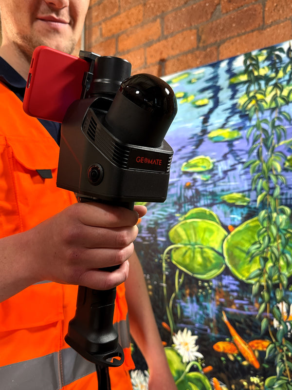
GeoMate GS100: SLAM 3D scanning with GNSS RTK
The GeoMate GS100 combines GNSS RTK, laser scanning and visual SLAM in one handheld system.
That combination gives you flexibility across indoor and outdoor environments. GNSS RTK provides positioning where satellite signals are available. SLAM and visual information support capture where those signals are weak or unavailable.
The GS100 offers:
- Up to 5cm absolute accuracy.
- Approximately 1cm relative accuracy.
- A scan rate of up to 640,000 points per second.
- A range of up to 300m.
- A 360° × 270° field of view.
- IP64 dust and splash resistance.
- Hot-swappable batteries for continuous working.
- A loop-free workflow supported by GNSS and SLAM integration.
In simple terms, it is a versatile surveying scanner for projects that move between different environments.
Potential applications include infrastructure inspection, utilities, tunnels, underground mapping, construction verification, BIM and volume calculations.
You can learn more about the GeoMate GS100 or speak to our team about how it may fit your existing survey workflow.
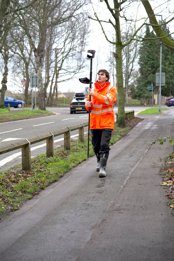
GeoMate SG100: contactless GNSS and LiDAR capture
The GeoMate SG100 is a visual-LiDAR GNSS receiver designed for contactless capture.
It provides typical accuracy of approximately 1.5cm and supports measurement of features up to 20m away without requiring physical contact.
That can be valuable when access is difficult, unsafe or disruptive. It may support work around structures, services, roadside assets and other features where direct measurement is not practical.
For infrastructure and construction professionals, contactless capture can help reduce the time spent positioning equipment around live or restricted areas.
Local support is part of the product
The right equipment is only one part of a successful reality-capture workflow.
You also need to understand how the system fits your project requirements, how the data will be used and what support is available when your team needs it.
This is where our experience matters.
At PQS Tech, we have more than 30 years of surveying expertise behind our technology offering. We understand that a handheld SLAM laser scanner may be used by a professional survey team, a construction engineer, a BIM technician or a wider site team.
Each user may need a different level of support.
Our approach is to provide clear guidance, practical product support and high-quality hardware training. We focus on helping your team use the equipment confidently within the requirements of its project.
Accuracy is not only a specification on a product page. It also depends on the survey environment, the deliverable, the checks required and the workflow used to capture and process the data.
We will help you assess those factors before you commit to a system.
Buy or hire, depending on your project
Not every organisation needs to purchase equipment immediately.
You may be testing a new workflow, covering a short-term increase in workload or delivering a project that requires specialist equipment for a defined period.
PQS Tech can support both routes. You can purchase GeoMate equipment for long-term in-house capability, or contact us about hiring surveying equipment when a hire solution is more suitable.
This gives you a practical way to evaluate the technology in the context of your own work.
What this means for the UK customer
The arrival of GeoMate under exclusive UK distribution gives the market more than another equipment choice.
It provides:
-
A clearer supply chain
GeoMate hardware is produced in Singapore, supporting greater visibility of equipment origin. -
A dedicated UK route to market
PQS Tech is the exclusive UK distributor, giving customers a clear point of contact. -
Local technical support
Help is available from a UK team with specialist surveying experience. -
Training alongside equipment
We provide high-quality hardware training so your team can build capability, not simply receive a product. -
Flexible access
GeoMate equipment is available to buy or hire, depending on your operational needs. -
Technology for varied applications
The range covers handheld LiDAR SLAM, GNSS-enabled SLAM 3D scanning and contactless capture.
This is a positive step for UK organisations looking for secure, high-performance geospatial technology with accountable local support.
A new option for your next survey
GeoMate is now available in the UK through PQS Tech.
Whether you are planning a measured building survey, infrastructure inspection, construction verification exercise or wider terrestrial laser scanning programme, we can help you understand which system best fits the work.
We can also support you if you need to compare purchasing with equipment hire, plan team training or assess how GeoMate could work alongside your existing survey equipment.
Get in touch with PQS Tech to discuss your project, request a demonstration or find the right route to GeoMate technology in the UK.
0 comments